Friday, September 14, 2012

New Map Lesson for Grade School

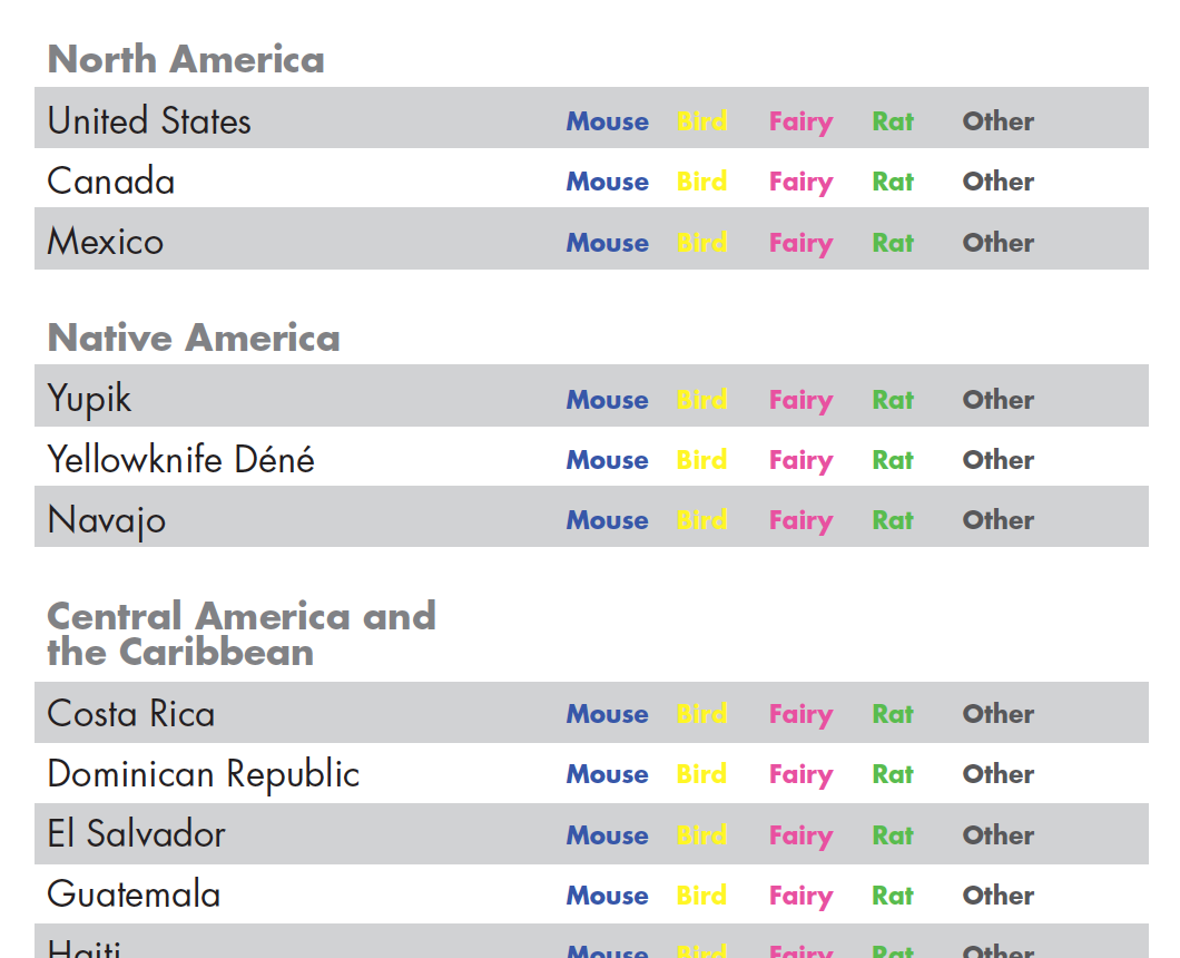
Throw Your Tooth on the Roof, a story about cultural traditions regarding the loss of baby teeth, offers a perfect opportunity for a map lesson for grade school students. Students are first required to synthesize and classify the data, then map it. Below, you can download the world map and the first exercise, which maps the creatures mentioned in the book that engage with the tooth or child once the tooth is lost.

Read the book to the children, ask them to circle the animal mentioned for each country. For countries that do not mention an animal, have the children "x" out that country.

Once through the story, have the children work through the list, coloring each country appropriately. There should be a category for "other" animals. The "no data" category should be different than "no animal" and this offers a great opportunity to discuss why.

Map


List


Friday, August 19, 2011

Natural Earth Data v.1.4 released

As of today, the data have been updated in Natural Earth Data. Through the hard work of many dedicated people, this public domain map dataset continues to be updated and remains one of the best sources for tightly integrated vector and raster data to make beautiful maps. According to Nathaniel Von Kelso, one of the principals working on the project "Natural Earth has been downloaded more than 250,000 times and is closing in on 1 million page views since launching in the final month of 2009." Here's a link to a full list of features and edits in this release. Congratulations to all who have contributed and who have used this data set to make beautiful maps!

Saturday, March 5, 2011

Submit your beautiful maps!

The U.S. National Committee of the International Cartographic Association (ICA) invites you to submit your current publications of maps, atlases, and other cartographic products to the Cartographic Exhibition at the 2011 International Cartographic Conference in France. The 25th International Cartographic Conference will convene in Paris the week of 3-8 July 2011.

The ICC Cartographic Exhibition is the premier international forum for displaying maps, atlases, and other cartographic products. It provides an excellent opportunity to feature the superior quality and diverse range of American cartography. Awards will be given by an international panel of judges to products exemplifying excellence in cartography. We encourage you to contribute to this exhibit.

Entry Forms must be submitted no later than March 15 to reserve space for your entry. A separate entry form should be submitted for each item. The information on these forms will be included in a printed catalog of exhibit items for conference participants.

What to enter:
U.S. Map Exhibit items must be received by April 15th, 2011.

Please provide:
two copies of any maps or panel displays
one copy of any table display (atlases, globes, etc.) or digital products

After completing the online Entry Form, send exhibit items to the U.S. Map Exhibit coordinator at this address by April 15, 2011:

Tanya Buckingham
Assistant Director
Cartography Laboratory
University of Wisconsin-Madison 
Science Hall, M390
550 N. Park Street
Madison, WI 53706

email: tbuckingham@wisc.edu

phone: 608-262-1363

Digital maps:
Digital map entries may be submitted on a CD/DVD (or via digital file transfer) to the U.S. Map Exhibit coordinator. Each CD or DVD must be labeled with the map titles, and simple, explicit directions on how to view the map. Send CDs or DVDs to the address above.

Entry restrictions:
Although we are encouraging all entries, space allotted to the United States portion of the Map Exhibition in the Paris meeting is restricted. Therefore, please limit your choices to your most outstanding products. Any item produced after January 2009 that was not exhibited at a previous ICA conference is eligible for the exhibition. All items selected for display will be donated to university libraries in Paris following the conference.

Wednesday, February 16, 2011

Seeking Maps for International Children's Map Exhibit


The Barbara Petchenik Map Exhibition aims to promote children's creative representation of the world, to enhance their cartographic awareness and to make them more conscious of their environment.

Students across the United States are invited to participate in the exhibit. Six maps will be selected from the maps received. Those maps will be displayed during the ICA conference as part of the International Map Exhibition, held as part of the 25th International Cartographic Conference of the International Cartographic Association in Paris, France, July 3-8, 2011

The theme of the exhibit for 2011 is: "Living in a globalized world"

Entry information:
The map must be produced by children under 16 years of age. Any item produced after January 2009 that was not exhibited at a previous ICA conference is eligible for the exhibition.

The international judging will focus on three criteria:
1) a recognizable message
2) cartographic content
3) the quality of execution.

Parameters of the entries:
1) the maximum size must not exceed A3 (420 mm x 297 mm or 17 x 11 inches)
2) the surface should be flat and pasted-on objects may not be higher than 5 mm or 0.2 inch and have to be thoroughly fixed.
3) the map can be made using any unbreakable material (thus no glass).
4) no moveable or folding-out parts covering sections of the drawing (Note: the submissions will be photographed or scanned and the complete drawing has to be visible in one scan or photo).
5) no perishable materials (like leaves of plants) may be used.
6) do not plasticize or laminate the drawings because that disturbs the physical appearance of the drawing.

Each map must have the following information on a label attached to the back side of the representation, in either French or English (the ICA's official languages):
1) author's name
2) author's age
3) school and address
4) author's country
5) map title

Please send map submissions by March 15, 2011:
Tanya Buckingham
Assistant Director
Cartography Laboratory
University of Wisconsin-Madison 
Science Hall, M390
550 N. Park Street
Madison, WI 53706

email: tbuckingham@wisc.edu
phone: 608-262-1363

If the entry is individual (not sent by a school) the author’s legal representatives (e.g. parents) will decide to make or not public their personal address. If the representatives do not agree to make it public, the official address of the ICA National Commission will be used for future contacts.

The winning entries will be submitted to international organizations (UNICEF International Art Committee or others) by the ICA Executive for consideration as greeting card designs or other kind of publication that might best showcase the maps created for the Competition. ICA may use them as well. Any participant must agree that his/her representation may be reproduced by the ICA or other international organizations, or scanned for publication on the Internet by Carleton University (on behalf of the ICA) without consultation or copyright fees.

Advertise the exhibit, by downloading the flyer.

Please peruse the digital collection at Carleton University Library. The work created by the children is incredible. While looking through the entries notice the diversity of countries involved in the exhibit.

More information:
A teacher's introduction to the Barbara Petchenik International World Map Design Exhibit.

Official rules

Not a child, but still want to display your work internationally? There is a Map Exhibit at the International Cartography Conference for everyone.

Friday, October 1, 2010

Need a map?

mapgiving is looking for clients.

We have had several people contact us in the past few months wanting to share their talent with you. From GIS professionals to people experimenting with 3D modeling.

We are looking for great organizations to match with these expert mapmakers.

If you can't think of a way that your group could use a map, email us for information on how a map can help achieve your goals: info@mapgiving.org

Thursday, December 3, 2009

Natural Earth Data web site now online!

Along with Nathaniel and Tom, Tanya and I are pleased to further announce the immediate availability of Natural Earth, free vector and raster map data at 1:10m, 1:50m, and 1:110m scales. This is a NACIS and MapGiving co-branded product with assistance from the University of Wisconson-Madison cartography lab, Florida State University, and others.

Nathaniel and Tom outline what this new collection of data are all about and go into detail about the why these efforts were undertaken. Get the full story on Nathaniel's blog: Kelso's Corner.


And you can get right to downloading this incredible (FREE!) cartographic data at: NaturalEarthData.com

Friday, June 12, 2009

Natural Earth Vector

We're excited to be helping with the next installment of Natural Earth data, Natural Earth Vector. A preview can be seen at: www.kelsocartography.com ...the unveiling will be at NACIS 2009 in Sacramento, and then available to share with the world.

Thursday, May 28, 2009

Technology, Trends and cartographyNEXT

Invitation to participate in a special issue of Cartographic Perspectives:
Technology, Trends and cartographyNEXT.

The approach and use of maps has dramatically shifted over recent years. This free, digital issue will provide an opportunity to begin closing the gap between theory and technology. It will discuss production techniques, open source/access data & software, knowledge & empowering people through maps.

So, what types of submissions are we looking for?

• critique a map: evaluating DESIGN and production METHODOLOGY, discuss or defy CONVENTIONS
• review open source or open access SOFTWARE, pros/cons and what's involved to make it work
• share your process for map PRODUCTION, describe your work-flow or specific style or treatment
• identify sources for FREE DATA and TOOLS. do you have a favorite widget or library/data warehouse?
• what do you do best? share that KNOWLEDGE and experience
• provide an EDITORIAL on your OPEN SOURCE experience (i.e., journals, software), why is it better? what are the challenges?

All submissions are due to Tanya Buckingham cartographyNEXT@nacis.org by August 1, revisions will be due four weeks later.

This additional fourth issue for 2009 will be released during the NACIS annual meeting in Sacramento, California, 7-10 October.

Get involved in what's NEXT.

Cartographic Perspecitives is the international journal of the North American Cartographic Information Society devoted to the study and practice of cartography in all its diversity. All content is peer-reviewed and indexed by Elsevier and via EBSCO Academic Search Complete.

Friday, May 15, 2009

Can't wait to see them...

I got a call from Tanya today saying that the batch of maps for Room to Read have been delivered to the client. The hard work of the wayfinders at XNR Productions should be up to see on the Room to Read web site soon... things are happening! More exciting mapgiving work to be featured soon...

Thursday, February 5, 2009

Still working on it!

We are working. We've been busy with project work, both finishing the first project and thinking about how to tackle the exciting new projects that have come our way.

We feel honored to be working with some wonderful people in the field and we're excited to be supporting not only community groups, but also our field.

Monday, December 8, 2008

Still working...

mapgiving has been humming quietly in the background of some big changes for me. We are moving along with the paperwork and clients have been contacting us, both through referrals and in response to some initial contacts that we made.

In the last few weeks, I have started work at the University of Wisconsin—Madison, Cartography Laboratory. My days are full of many different tasks. However, we are rolling along.

Bill Buckingham has some exciting new work that he'll be updating us about soon, in addition to some projects that are just getting off the ground now.

Friday, October 17, 2008

Geographic education

tanya
As part of the mission of mapgiving we would like to encourage everyone to become involved in geography and cartography. One of our current projects will be promoting the Barbara Petchenik Children's Map Competition. I am the national coordinator of the competition and will be collecting maps throughout the year to submit to the International Cartographic Association in the spring, the conference will be held in Santiago, Chile.

In addition to organizing the national competition, I would like to continue the discussion I began with the Library of Congress for the last competition to create a repository of all of the maps that are submitted from students throughout the United States.

For more information about the competition please contact me: tanmabuck@gmail.com.

Here are the five maps selected from more than 100 submissions for the 2007 competition.


The last one...

Please feel free to download the third map produced during the kick-off event. We will be working with the client to make adjustments over the next couple of weeks.

Thursday, October 16, 2008

Asking questions...

It turns out that we have many more questions than answers at this point in the process. How do we start, who do we talk to? We started by contacting a patent lawyer, we will plan to speak with an accountant shortly and we are defining clearly and concisely what mapgiving is and what the mission is. We will share our lessons and bumps in the road as we progress through this process.

Tuesday, October 14, 2008

One of the print maps...

The larger scale print map can now be downloaded. The map showing the trail extension will be posted after a few tweaks.

I am reminded of how much I love these people...

In the whirlwind of mapgiving, the planning, the production, the enormously excited reception that we had, and then the busy days of the conference following the event, I did not have time to really think about what had happened.

As things begin to settle in Madison, and I return to my daily tasks, I've had some time to process the events of the past week and several months. We have asked the Wayfinders to provide some feedback about their experience and how they see the organization of mapgiving growing and formalizing from this point. We are just beginning to read through these comments, and reliving the event through their words fills my heart. We really have something here and we will spend the next couple of weeks asking questions, and finding answers. The company where I work, XNR Productions, is extremely supportive of this mission and is supporting me in this exploration process. I couldn't be happier to have such a supportive network of people, through NACIS, XNR and the amazing group of people who participated in the kick-off event and those who have expressed interest in furthering the mission of mapgiving. The mission of cartographic and geographic education, collaboration and communication.

Web team map

To see the web team map, visit mapgiving. The print maps will be on display later today.

the Wayfinders speak...

Nick Springer of Springer Cartographics talks of his experience.

Wednesday, October 8, 2008

Local coverage of the mapgiving kick-off

The Missoulian Newspaper, on-line and print showed up to cover the event...see the video.

A few favorites from the later hours...

Notice the celebration of Nick and Jim finishing their tasks. Also, notice the smirk on Jeremy's face. He knows he has hours of work left to complete.


Brandon, heckling the participants...and trying to help.


Everyone is hard at work!


What is that?


Astounding data issues...5 layers of this lake, and none of them line up properly.


Nice!


Lou had enough mapping and decided to nap on the map twister.


A brief glimpse of one of the print team maps.